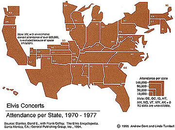
Cartograms
The concept of relative space has been developed in geography and cartography during the 1960's. One of its main devices are cartograms, two dimensional representations of relative space. Once again, the parameter that defines distance and space can be completely arbitrary. This map of the states is for example scaled according how many people in each state attended an elvis concerts.
source: http://www.owu.edu/~jbkrygie/krygier_html/geog_353/geog_353_lo/geog_353_lo03.html