the
rush hour slope
Temporal
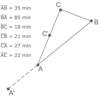
distances are usually asymmetric - the distance from point A to point
B might be considerably different than the distance from B to A.
This asymmetry can be expressed in the steepness of the terrain. If the movement is against the stream and the opposite direction is much faster, it is like going up a steep mountain. If we are on the faster track, it is like going downhill. This metaphor is the basis for the following environments. The difference in the two velocities is mapped on the vertical axis.
The Model is inspired by M. Fujihata's project 'impressing velocity', in which the shape of mt. fuji was reproduced using the velocities of GPS-equipped hikers.
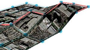
based on the speed maps delivered by the ATSAC ( Automated Traffic Survillance and Control ) system
3d environment - get virtools player